Socrates - Comenius 1:
School Project “We are all living under the same sky”
![]()
|
Socrates - Comenius 1: |
|
|
| |
Geography
Location of the Czech republic
The Czech Republic is a land-locked country situated in the Central Europe. It covers the area of historical countries such as Bohemia, Moravia and a part of Silesia. This country borders on Germany (810 km), Poland (762 km), Austria (466 km) and Slovakia (252 km).
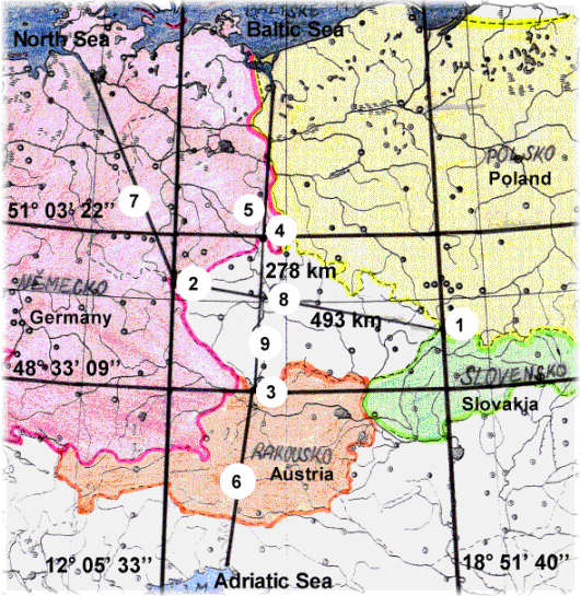
The total length of the border is 2290 km. The size of the Czech Republic is 78866 square metres. The position is determined by geographical coordinates of boundary points.
The northernmost point – (4) Lobendava near Sluknov (51o 03’ 22’’ of latitude north). The southernmost point – (3) Vyssi Brod (48o 33’ 09’’ of latitude north). The westernmost point – (2) Krasna near As (12o 05’ 33’’ of latitude east). The easternmost point – (1) Bukovec near Frydek-Mistek (18o 51’ 40’’ of latitude east)
The length of the country form the west to the north is 493 kilometres (8). The width of the country from the north to the south is 278 kilometres (9).
Geographical centre (centre of gravity) of the country is at the village “Cihost” near Ledec nad Sazavou (district – Havlickuv Brod).
The nearest coast is in Sczecin bay at the Baltic Sea (5) – 310 km, in Triest at the Adriatic Sea (6) – 330 km and at the mouth of the Elbe into the North Sea (7) – 380 km.